Quick editorial note: So, I’m so sorry. I made a mistake. On my posts for days 2 and 3, I had referred to the Flatirons as if they were this sprawling range of foothills. After more research, I discovered that the name only refers to the five large sandstone formations that dominate the foothills on the west side of Boulder. So when we thought we were exploring the Flatirons, we actually were exploring the Front Range, the range of mountains in the Rockies that runs from Casper, Wyoming to Pueblo, Colorado. You’ll notice those corrections as you read on.
After we discovered that we had barely actually driven on Left Hand Canyon Drive during our excursions from the previous day (the James Canyon Drive that we did find ourselves on was still well worth it), and on account of the sudden snowfall that obscured our views of the Flatirons Front Range that day, we wanted to spend part of today re-exploring the Flatirons. But before we got to any of that, Kevan (Amy and Aaron’s Air BnB host in the Lower Arapahoe neighborhood of Boulder) recommended a hike on the Viewpoint Trail.
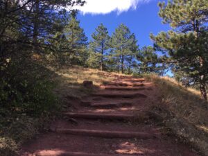
If you’re like me and you generally dislike most people, you will love a hike on the Viewpoint Trail, especially on a weekday, because since the trailhead doesn’t have a parking lot for cars making it obvious that there is a trailhead (or anything, for that matter) nearby, I get the impression that most people would rather enjoy a hike that is clearly marked with a parking lot rather than one is not, therefore attracting hoards of people. As such, I counted probably four other people on the entire hike, so not only did the hike provide gorgeous, gorgeous views of Boulder, but we were also able to enjoy the hike with minimal interactions with other people.
The trail itself starts in the Lower Arapahoe neighborhood near Eben G. Fine Park (there’s another entrance right off of University Avenue as well), and while its location isn’t marked clearly with a parking lot, you can still find small diamond-shaped signs attached to telephone poles pointing the way. The trail is also a nice “warm up” trail, I suppose–one that I recommend you compete early on during your visit to Boulder: it’s short and generally unchallenging and doesn’t have great sections where you have to navigate a trail marked only by stones and boulders and no path. That said, we did find ourselves needing to stop and rest occasionally, but that was more on account of how we’re not fully adjusted to the high elevation. (Apparently, it can take up a to a week for the body to catch up and make enough red blood cells to carry enough oxygen should you find yourself in an elevation higher than you’re used to.)
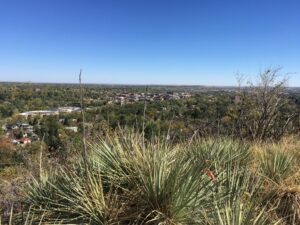
As we made our way from the base of the trail to the summit, not only were we treated to some of the best views of Boulder, we also got to admire some of the local flora. I was particularly fascinated with these hearty succulents with stiff, spiky leaves that radiated outward to a spiky point. Later I looked them up, and I believe they are called plains yucca or yucca glauca. It was too late in the season to see these particular yucca with their tall, blossoming stalks, but these plants growing enthusiastically in dry desert-like soil did serve as a reminder that, according to the Köppen climate classification system, Boulder is situated in a climate that is technically semi-arid and sometimes humid subtropical.
Once we reached the summit of the Viewpoint Trail, we were treated to a unassuming lookout point that not only provided us with more stunning views of Boulder and its surrounding environs, but also provided us with some placards that informed us of the prehistoric history of the landscape, how Boulder came to be settled by European invaders, and how much of the surrounding landscape around the city is protected and won’t be developed. So, all in all, the Viewpoint Trail has been a real highlight of our trip so far, and I highly recommend a visit.
Following the trek back down the trail, we found ourselves a tad bit peckish, so we decided to walk into town to check out one of the many restaurants Pearl Street has to offer. It had been quite windy on the hike, but by the time we got farther into town, the wind had died down. (In fact, we were a little worried about finding a restaurant where we could eat outside, on account of COVID.) We were very excited to try out a Himalayan restaurant called Sherpa’s, but they bizarrely told us they were only seating inside due to the wind. When we told them the wind had died down, they still wouldn’t seat us. So we tried elsewhere, remarking under our breath, “I’m sorry. Isn’t the service industry suffering right now? Did they really turn us away because it was windy outside but is no longer?”
Fortunately, there were countless other restaurants downtown that were seating outside, so we decided to check out a restaurant called Bar Taco. I was disappointed to discover that they were a chain, having established locations in 12 different states across the country, but everything was still fine just the same. They’ve joined an ever growing number of businesses where visitors can download the menu from their phone using a QR code affixed to the table (remember when we used to make fun of QR codes?) in order to minimize needlessly touching things like pieces of paper with menus typed on them. It also helps minimize talking to other people to continue mitigating the spread of COVID: we were able to order on our phones and also pay on our phones, and should we have needed anything, we could have either just placed a laminated card in a tall stand on the table or just ordered more food and drink through the online menu. I got to enjoy a roasted duck rice bowl and a bourbon drink called an old thymer (basically a manhattan except with thyme, lemon, and orange added). As I said, everything was fine. The service was great, of course, but the food basically only met my expectations for what food should be. It was actually at this point in our journeys that I was worried that average food with great service was a portent of things to come for the rest of our stay here.
Following lunch, we hopped in Amy and Aaron’s rental van (windows down; masks on) to drive the full length of Left Hand Canyon Drive. To do that, I’d recommend you do what we did: we drove north on Highway 7 and then north on Highway 35 all the way to a small town called Altona. Left Hand Canyon Drive begins in this town and winds ever so slowly through the Flatirons Front Range, tracing Left Hand Creek as you go, and terminating in another small town called Ward where the drive meets up with Peak to Peak Highway.
Something we’ve been told by not only Kevan but also my own Air BnB host was that we arrived in Colorado in time for peak autumn colors. However, we’ve consistently been disappointed by what colors actually are on display. Perhaps we actually just missed peak color season altogether, as all we’ve seen so far are mildly lackluster colors of sleepy sunshine yellows. On the other hand, a couple weeks ago on the North Shore in Minnesota, for example, we had just been treated to blazing oranges, crimson reds, and brilliant golds that all majestically painted the landscape in an eclectic celebration of maximally saturated color. I’m not sure if the Flatirons Front Range just don’t didn’t have any variety of trees beyond ones that yield a listless selection of unimaginative yellow hues, but–all thing’s considered–the autumn colors have been ever so slightly disappointing. That said, a drive through Left Hand Canyon Drive is still well worth it, as the road winds and twists and turns through the rocky foothills of the Flatirons Front Range, providing views of incredible summits, sheer rocky drops, crisp refreshing creeks, and dense forests of tall, stately evergreens.
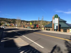
Once we arrived at the western terminus of Left Hand Canyon Drive in the (frankly) dumpy town called Ward, we decided to head south on Peak to Peak Highway, which took us to a lovely town (that wasn’t dumpy) called Nederland. If you want to experience a cute, small, mountain town at its best, I’d recommend an excursion to Nederland. We initially stopped to energize ourselves on tea and coffee, but the shop that interested us, Blue Owl Books, was closed for the day; a real shame since the shop exuded a mountainy charm with its whimsical name, walls of books, and enticing menu of baked and caffeinated goods. Around the corner, however, we discovered an alpaca shop that exuded even more mountainy charm called Alpaca Store and More. We got to meet Roy Burkett, the owner, who purchased the shop some years ago, he himself a folk musician from Alabama. We also met the shop’s counterpart who works there only on Mondays (and I’m so sorry, I’m forgetting her name, but please don’t infer from my lapse that she was in any way unmemorable), who had a knack for guessing shoe sizes and sweater sizes. After enjoying a thorough perusal of socks, sweaters, blankets, and small stuffed toy alpacas, I myself found myself walking out of the store with a cozy, cozy alpaca zip-up sweater and a pair of alpaca socks. Amy and Aaron likewise purchased a diverse selection of socks that surely will keep us all warm on cold Minnesota winter nights. And while the wares are on the expensive side, please remember that the goods all come handmade from Peru and will last a lifetime. So, basically, do go to Alpaca Store and More, as it’s absolutely lovely!
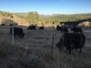
Following our visit to Nederland and on account of construction on the main road, Highway 119, that connects Nederland to Boulder, we decided to head back on Magnolia Road instead. Much of this road is gravel, and so it allows for a serene and tranquil drive through the foothills where we got to see more incredible vistas as well as expansive ranches that usually had bison roaming the fields. At one point, we stopped so I might try to pet a bison, but they are not exactly warm to human guests and I’d recommend you just stay in your car. I tried to slowly approach towards a bison (who was behind a fence that probably wouldn’t hold them anyway), eyes averted away, hand outstretched, palm up, as a gesture of good faith (all I needed was a literal olive branch to be even more welcoming), but the bison only gave two, fierce, upward thrusts of its head and neck to tell me that they weren’t amused. So, I stayed in the car for the remainder of the drive.
Shortly after the encounter with the bison, however, we were treated to a glimpse of some elk that were nearby. We even got to listen to their calls: a kind of high pitched whistle accompanied by a low grumble, two sounds happening at once. However, just as the one bison wasn’t a fan of my approach earlier, they also weren’t a fan of the elks’ presence nor their somewhat eerie yet musical vocalizations, as the bison chased the elk away from their turf. Here’s a video I made on my phone that captured the calls of the elk:
Our day concluded with some chat and beers at Amy and Aaron’s Air BnB. We frequently found ourselves quite tired by the end of the day, often retiring for the evening by 9:30pm or so, even though it felt like we didn’t do all that much. We chalked up our energy levels to the higher elevation, however, as a few thousand feet really does make a difference.
Check back soon where I shall write about what we did on our third full day here: more food on Pearl Street and a stroll through town by Columbia Cemetery and Chautauqua Park, where we found out that Boulder really does have hippies and communists in addition to artists.
Stray observations:
- While in Nederland, I saw a bus stop, which I thought was out of place in a small, small mountain town. However, I was pleased to see that there actually is a bus line that runs east/west from Boulder all the way to Eldora. Sadly, it appears the bus only comes once an hour.
- Even out in the mountains away from liberal Boulder, Biden/Harris signs were aplenty, which was reassuring.
